Building POI-rich marina datasets for safer water sports navigation


Anishma Suresh

Content Marketer

12,000+ marinas

100% coverage

95% data accuracy

Overview

A global maritime tech company reached out to us with an interesting requirement. They wanted to build a marine navigation product just for water sports enthusiasts. This company is traditionally focused on commercial maritime sectors like ports, shipping companies, and harbor authorities.

They provide these sectors with digital marine navigation tools (ENC chart server), real-time AIS marine vessel tracking and fleet management systems, and an integrated marine traffic tracker for web-based marine traffic tracking solutions. The client wanted to expand into the recreational space with a solution to help water sports enthusiasts explore coastlines safely and confidently.

They approached Xtract.io to acquire a reliable POI dataset of marinas across the United States and Canada to update their current database. Their goal was to improve routing by upgrading their marine traffic tracker and safety, and deliver rich experiences for sports enthusiasts exploring coastal waters through better marine mapping capabilities.

Challenges

This global maritime tech company decided to start close to home, starting with Canada and the US. But they faced a few unexpected challenges with compiling data.

  • The first challenge was the fragmented nature of the marina information that is available online. These data are found across outdated websites, PDF brochures, and local listings, which were hard to consolidate and standardize. 
  • Second, many sources lacked key details like LOA (Length Overall) limits, VHF contact channels, or information on amenities such as fuel depth or after-hours access. Gathering this information is especially tricky given how frequently these attributes change with seasons, upgrades, or policy shifts.
  • Another challenge was attribute consistency. Fields like “dockage type” or “fuel available” might appear under different terms, formats, or units depending on the source. 
  • As this data would be supporting a real-time marine navigation product, reliability was non-negotiable because the client could not afford to risk the data becoming outdated shortly after launch.

Solution

Our solution combined advanced data processing, smart validation, and real-time updates to tackle these challenges head-on. Instead of just pulling data from scattered sources, we carefully gathered, cleaned, and standardized everything to fit the client’s specific needs. 

Our proprietary extraction tools helped standardize this scattered information into a unified, structured format. To keep the dataset relevant, we built smart update workflows that flag frequently changing fields and prioritize them for periodic revalidation using a mix of automated crawls, source monitoring, and manual checks. 

We also handled attribute inconsistencies by mapping varied terms and units into a unified schema, utilizing transformation rules and NLP techniques to standardize data across sources, laying the foundation for accurate marine mapping and seamless integration.

Our extensive experience in location intelligence and data enrichment enabled us to collect and deliver a high-quality, structured dataset.

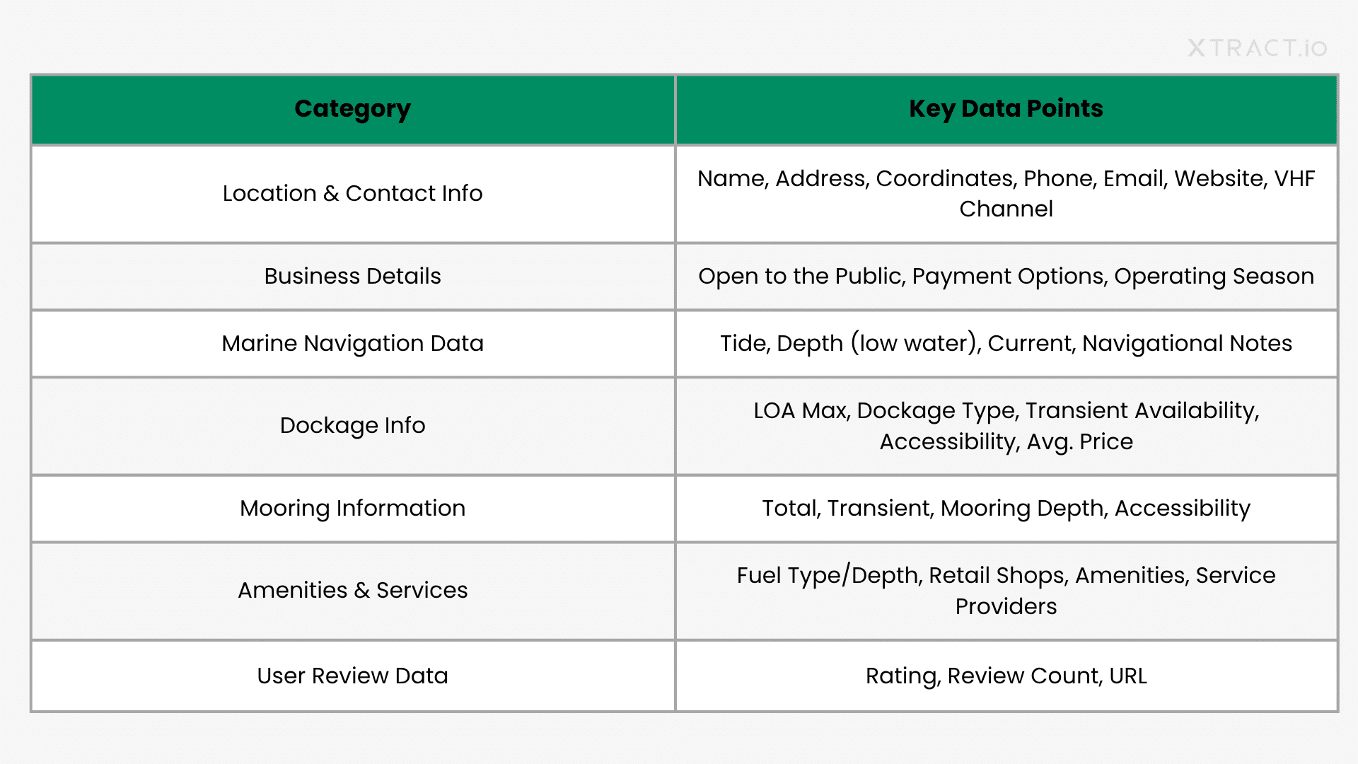
Below are some of the key data attributes we delivered:

Result

We delivered to the maritime tech company a clean and well-structured POI dataset of over 12,000 marinas across the US and Canada. It helped them strengthen their product offering and expand into a brand-new market through accurate marine mapping.

Also, with over 50+ standardized attributes, the client was able to launch a user-friendly marine navigation product built on a marine traffic tracker for finding marinas based on specific needs, making coastal exploration safer and more enjoyable.

We also personalized the data to support five key recreational water sports:

  • Jet skiing & Personal Watercraft (PWC)
  • Kayaking & Paddleboarding
  • Sailing & Cruising
  • Sport Fishing
  • Coastal Touring

The data was delivered in formats such as GeoJSON, custom JSON, CSV, and SQLite to work with their existing marine navigation system. Because of this, they could

  • Reduce time-to-deployment 
  • Minimize integration overhead 
  • Ensure that data can power real-time features

© 2025 Xtract.io Technology Solutions Pvt Ltd | All Rights Reserved | A Mobius Venture.

© 2025 Xtract.io Technology Solutions Pvt Ltd | All Rights Reserved | A Mobius Venture.