The Business Need
A UK-based well-established business intelligence service provider, also known as a decision-making partner of 300+ fuel and convenience retailers in over 70 countries, approached Xtract.io for location data services. The company is primarily into providing location planning, network transformation, and data intelligence services to its customers.
The company wanted Xtract.io to create geofences along with access points and provide remote survey assistance services for 6000+ quick-service restaurants (QSR) across 13 cities in the U.S. The objective of this data is to determine the optimal site location and make strategic business expansion plans.
Challenges
The company provided two data inputs, i.e., QSR name and address. With these two inputs, Xtract.io had to deliver polygon data along with other associated location data attributes surrounding the QSR such as -
Location type, if it is in a main business or commercial centre of the town/city
Primary street, secondary lane, and the local network of roads connecting the QSR
The geographical direction at which the QSR is located
Polygon of a shopping mall, if the QSR is located inside a mall
The appearance of the building - if the building is new, old, requires renovation, etc
If the QSR has a drive-through facility
To determine the level of landscaping near the QSR
Traffic lights, barriers, etc. around the QSR
The required type of data is unavailable in the public domain and requires extensive SME knowledge in Geographic Information System (GIS) and understanding the lanes and streets from the maps. It was also challenging to deliver the final quality output to the client in a short turnaround time of 15 days. But, a team of GIS Engineers from Xtract.io did it. Want to know how? Read more.
Xtract.io Analysis & Solutions
At the flexibility & comfort of sitting in one place & selecting optimal sites from other parts of the world, Xtract.io provides a complete remote survey assistance services to its clients using information available in online Maps
To begin with, our GIS Engineers researched, analyzed & understood the nuances of geospatial views to provide accurate values for a set of attributes pre-defined by the customer.
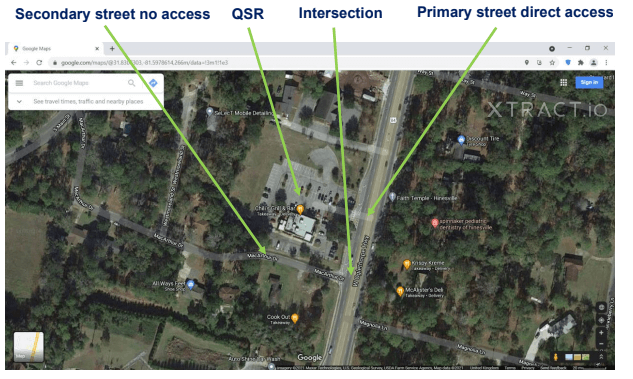
First, QSRs are verified by obtaining coordinates using the aerial view window from Gmaps. Using the aerial view or street view of the map, the connecting roads, the appearance of the building, the direction in which the QSR is located, barriers, traffic lights around the QSR are determined and captured.

Source: Created and developed by team Xtract.io
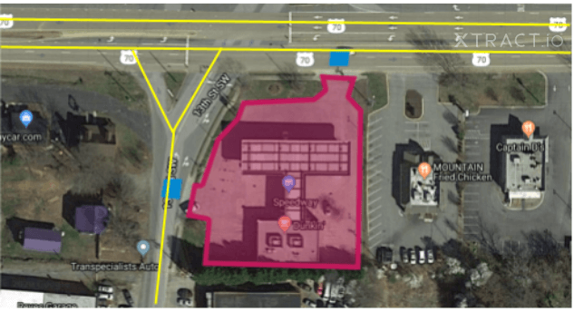
Further, polygons are drawn (as shown below) using suitable software such as QGIS and Mapinfo. Using both the types of view, location type, and connecting lanes to the QSR are identified.

Source: Created and developed by team Xtract.io
Xtract.io, known for its accuracy, quality checked these data points by “Process Excellence Group (PEG)”, a group of subject-matter experts who scrutinizes the data to ensure that it is as per the client's request.
Results & Outcomes
The client was able to take a look at the QSRs and their surroundings with Xtract.io data. This further assisted the client to make strategic business decisions for their store expansion.
POI data related to 6000+ QSRs with 30 unique attributes were delivered to the client in a short turnaround time of 15 days
The requested data was shared in excel format, however, Xtract.io also shares data in the portal or customer dashboard, as per requirements.
With a quality score of 95%, Xtract.io delivered the required dataset to the customer.


